


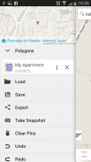


وصف لـ Measure Map Lite
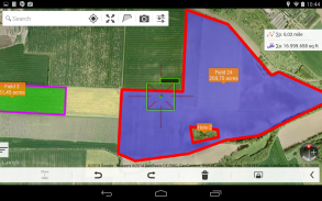
Measure Map Lite lets you quickly and easily draw polygons and measure distances, perimeters and areas over Google Maps and many other map sources with laser sharp precision. It even takes into account the curvature of the earth’s surface. Use it for small areas or large, then share your findings via any sharing app on your device.
You may be an architect, a sports enthusiast or a geography hobbyist. It doesn't matter why you have a keen interest in accurate distances, it just matters that you have the tools to satisfy your need to know them.
That’s what Measure Map is for, to put a powerful, portable measuring tool right in the palm of your hand. Your Android device can now provide you with totally precise measurements of any distance, from as small as a meter to as big as thousands of kilometers or miles, even taking the curvature of the earth’s surface into account when measuring. It does all that, fast and effortlessly.
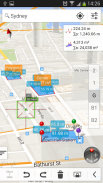
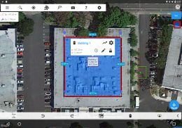
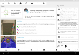
You don’t need a degree to take advantage of what Measure Map offers. Just drag the cross-hair, plunk pins in to mark the area you want measured and – boom! It’s done. Easy, right?. The "Magic" button allows you to input points more easily without losing it's professional accuracy.
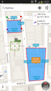
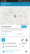
The app measures any distance, route, or area you want, over Maps. Want to calculate your drive on the golf course, or maybe find out the distance of that marathon you’re thinking of entering? Go ahead. Need to know the size of a parcel of arable land for your company? You can do that, too.
<b>
The restrictions of the Lite version are:
* You can only create one polygon with a maximum number of 6 pins.
* No shapes: Cannot create a circle nor a rectangle.
* No extra maps.
* No Track Button.
* Only loads MMP files.
* Ads.</b>
Check out the impressive features you get in Measure Map:
* Extra Maps: You can purchase Bing Maps, Here Maps, Apple Maps, Arc GIS, World Street Map, Map Quest, Open Street Map, Open Cycle Map, USGS Maps and Yandex Map in one package in the same app. <b>NOTE: You need to upgrade to Measure Map Pro to be able to purchase this feature.</b>
* Attractive, smooth, easy navigation and use
* Elevation Profile and altitude of a route.
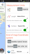
* Displays Maps View: Map, Satellite, hybrid and terrain
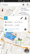
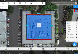
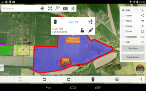
* Operations: Add, delete intermediate pins, insert between pins, move pins, get info
* Undo and redo operations as needed
* Search for current location, text (villages, places of interest, etc.) or an area or route
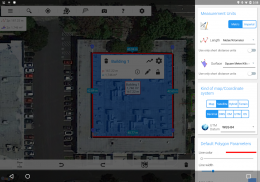
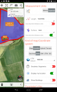
Works for Metric and Imperial measurements
* Length units: meters, kilometers, feet, yards, miles, nautical miles, ken, ri, bù, lǐ, link, chain.
* Surface units: square meters and kilometers, area, hectares, square foot, square yards, square miles, acres, fanegas (Valencian, Castilian or Colombian), tsubo, bu, so, lí, mǔ
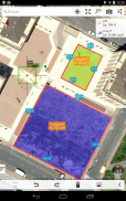
* Ability to select color and thickness of the perimeter line.
* Ability to select the color and transparency of the selected area.
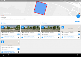
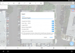
* Exporting formats: Measure Map, KML (G00GLE Earth), CSV (Excel), Image (PNG) and PDF
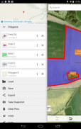
* Export and import of surfaces and routes via your storage services account.
* Save to photo album.
* Download surfaces and routes from the Internet.
If precise measurements are important or interesting to you, this is the app you need. You won’t find one that is better, more accurate and easier to use.
Download Measure Map now but be warned – measuring may become an obsession.
<b>Developer: Shaji.</b>
</div> <div jsname="WJz9Hc" style="display:none">قياس خريطة لايت يتيح لك بسرعة وسهولة رسم المضلعات وقياس المسافات، محيط المساحات وخرائط جوجل والعديد من المصادر خريطة أخرى مع دقة الليزر حادة. حتى أنها تأخذ في الاعتبار انحناء سطح الأرض. استخدامه لمناطق صغيرة أو كبيرة، ثم تبادل النتائج الخاصة بك عن طريق أي تطبيق المشاركة على جهازك.
قد تكون مهندس معماري، لعشاق الرياضة أو الهاوي الجغرافيا. لا يهم ماذا لديك اهتماما كبيرا في مسافات دقيقة، يهم فقط أن يكون لديك الأدوات اللازمة لتلبية الحاجة الخاصة بك أن تعرف عليها.
هذا ما هو مقياس خريطة ل، لوضع قوية، أداة قياس المحمولة الحق في راحة يدك. يمكن جهاز الروبوت الخاص بك الآن توفر لك مع قياسات دقيقة تماما من أي مسافة، من صغيرة مثل المتر إلى كبير مثل الآلاف من الكيلومترات أو الأميال، حتى مع أخذ انحناء سطح الأرض في الاعتبار عند قياس. وهو يفعل كل ذلك، بسرعة وبدون عناء.
أنت لا تحتاج إلى درجة للاستفادة من ما مقياس خريطة العروض. مجرد سحب الشعر الصليب، غطس المسامير في لاحياء المنطقة التي تريد قياسه و- الطفرة! تم التنفيذ. من السهل، أليس كذلك؟ على زر "ماجيك" يسمح لك لنقاط المدخلات أكثر سهولة دون أن تفقد انها دقة المهنية.
التطبيق يقيس أي مسافة، والطريق، أو المنطقة التي تريد، على خرائط. تريد حساب محرك الأقراص على ملعب للجولف، أو ربما معرفة مسافة الماراثون التي كنت تفكر في الدخول؟ انطلق. بحاجة إلى معرفة حجم لا يتجزأ من الأراضي الصالحة للزراعة لشركتك؟ يمكنك أن تفعل ذلك أيضا.
قيود النسخة لايت هي:
* يمكنك فقط إنشاء مضلع واحد مع أكبر عدد ممكن من 6 دبابيس.
* لا يوجد الأشكال: لا يمكن إنشاء دائرة أو مستطيل.
* لا يوجد خرائط إضافية.
* لا يوجد زر المسار.
* يقوم بتحميل ملفات المشاركة المتناقصة فقط.
* إعلانات.
تحقق من الميزات الرائعة التي تحصل في مقياس الخريطة:
* خرائط إضافية: يمكنك شراء خرائط بنج، هنا خرائط، خرائط أبل، قوس GIS، العالم شارع الخريطة، خريطة كويست، فتح شارع الخريطة، دورة مفتوحة خريطة، خرائط USGS وياندكس خريطة في حزمة واحدة في نفس التطبيق. <b> ملاحظة: تحتاج إلى الترقية إلى قياس خريطة برو لتكون قادرة على شراء هذه الميزة
* جذاب، على نحو سلس، سهولة التصفح والاستخدام
* ملف تحديد الارتفاع والارتفاع من الطريق.
* عرض خرائط الشخصي: الخريطة، الأقمار الصناعية، الهجينة والتضاريس
* العمليات: إضافة، حذف دبابيس وسيطة، وإدراج بين دبابيس، نقل الدبابيس، والحصول على معلومات
* تراجع وإعادة العمليات حسب الحاجة
* البحث عن الموقع الحالي، والنص (القرى والأماكن ذات الأهمية، الخ) أو منطقة أو الطريق
يعمل لمتري والقياسات الامبراطوري
* وحدة طول: متر، كم، قدم والساحات، ميل، ميل بحري، كين، ري، بو، lǐ، وصلة، السلسلة.
* وحدة السطحية: متر مربع وعلى بعد أو المنطقة أو هكتار، قدم المربع الواحد، ياردة مربعة، ميلا مربعا، فدان، fanegas (بلنسية، القشتالية أو الكولومبية)، تسوبو، بو، لذلك، لي، mǔ
* القدرة على تحديد لون وسماكة الخط محيط.
* القدرة على تحديد اللون والشفافية في المنطقة المحددة.
* تصدير الأشكال: قياس الخريطة، KML (G00GLE الأرض)، CSV (اكسل)، صورة (PNG) وPDF
* تصدير واستيراد الأسطح والطرق عن طريق حساب خدمات التخزين الخاصة بك.
* حفظ إلى ألبوم الصور.
* تحميل الأسطح والطرق من الإنترنت.
إذا قياسات دقيقة مهمة أو مثيرة للاهتمام بالنسبة لك، وهذا هو التطبيق التي تحتاج إليها. لن تجد بالتي هي أحسن، وأكثر دقة وأسهل للاستخدام.
تحميل مقياس خريطة الآن، ولكن حذر من أن يكون - قد يصبح قياس هاجسا.
المطور: شاجي
</b></div> <div class="show-more-end">
Measure Map Lite - إصدار 9.2.0
(15-05-2023)
Measure Map Lite - معلومات APK
نُسخة APK: 9.2.0الحزمة: com.globaldpi.measuremapliteتطبيقات من الفئة نفسها
قد يعجبك أيضًا...


